Blog Categories
Most popular blog posts
Like this Blog
Latest blog posts
Latest blog comments
Most active Bloggers
Categories
|
|
by Linus
01.08.2017 09:33
|
|
A rather interesting severe weather situation in Central Europe today, and quite a potent one at that, with ESTOFEX issuing one of its rare Level 3 threats for northeastern Germany. While the cluster of thunderstorms that moved across Germany last night is slowly dying in the northeast, a new one is moving in from France in the southwest, with the strongest individual thunderstorms (as is usual for clusters) being at the southern edge.
There is a lot of potential in the atmosphere, and many parts along the route of the thunderstorms from the southwest to the northeast will reach temperatures over 30°C, some even close to 36°C.
This gives the thunderstorms the abilities to grow into really severe individual storms. The risks include storm gusts that may reach up to 100 to even 125km/h at times, hail with diameters of up to 5 - 8cm, flash flooding (with rain rates of around 40 liters in an hour) and an elevated risk for even strong tornadoes.
The storms will have the energy to continue well beyond sunset and even into the morning hours of Thursday.
++++++++++++++++++++++DEUTSCH+++++++++++++++++++++
Eine ziemlich interessante Unwetterlage heute in Mitteleuropa, die auch durchaus viel Potential aufweist, was ESTOFEX dazu gebracht hat, eine ihrer seltenen Level 3 Warnungen für den Nordosten Deutschlands auszugeben. Während der Gewitter-Cluster der sich letzte Nacht über Deutschland bewegt hat sich im Nordosten jetzt langsam auflöst, bewegt sich schon ein neuer aus Frankreich im Südwesten in das Bundesgebiet. Die stärksten individuellen Gewitter in diesem Cluster sind, wie es normal ist für solche Gruppierungen von Gewittern, derzeit am südlichen Rand zu finden.
Es ist heute viel Potential in der Luft, und viele Orte entlang der route der Gewitter von Südwest nach Nordost werden heute nochmals Höchstwerte über 30°CC, zum Teil auch 36°C, erreichen.
Das ermöglicht es den Gewittern zu kräftigen Unwettern heranzuwachsen. Die Hauptgefahren sind unter anderem Sturm- oder Orkanböen bis 100 oder sogar 125km/h, Hagel mit einem Durchmesser von bis zu 5-8cm, Starkregen (Regenraten bis 40 liter in einer Stunde) und ein erhöhtes Potential sogar für starke Tornados.
Die Unwetter werden die nötige Energie besitzen um bis tief in die Nacht durchzuhalten, manche sogar bis in die Morgenstunden des Donnerstags.
|
|
by Linus
01.08.2017 08:51
|
|

ESTOFEX, in its thunderstorm forecast for today, has issued a rare Level 3 threat for parts of Germany, Poland, Russia and Lithuania.
The main risks in the Level 3 area over Germany and far NW Poland are severe or damaging storm gusts, large or very large hail, flash flooding and the potential for strong tornadoes.
The main risks in the Level 3 area over the far NE of Poland, Kaliningrad, and parts of Lithuania are severe or damaging storm gusts, large or very large hail, flash flooding, and the potential for strong tornadoes.
In the Level 2 area stretching all the way from France and Switzerland to Latvia and Lithuania, the main risks are severe wind gusts, large or very large hail, flash flooding and the potential for tornadoes.
In the Level 1 area, which reaches all the way from Spain to Estonia and Russia, there are the same risks as in the Level 2 area, however there is less potential for severe development.
|
|
by Linus
28.06.2017 08:22
|
|
++++++++++++++++ENGLISH+++++++++++++++
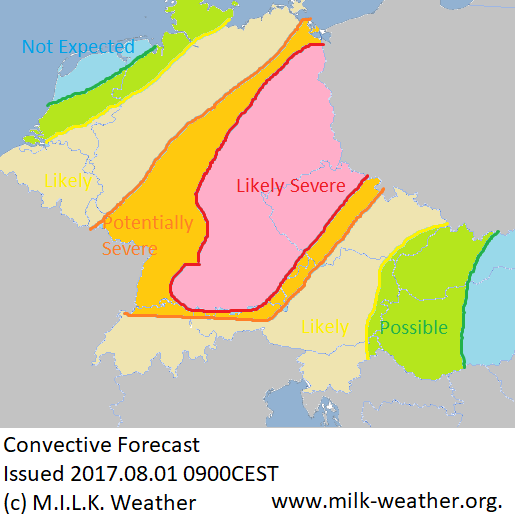
Thunderstorms are possible throughout all of central Europe today, fueled by the temperatures that will reach around 30°C in most parts, and kicked off by a cold front moving in from the west / southwest. Especially in the eastern and southern parts of the forecast area, the potential for strong thunderstorms is given.
The risk of severe thunderstorms is highest in Slovenia, where there may be (in the order of likeliness) torrential rainfall, large to very large hail and the potential for tornadoes given. To a lesser degree, the risk of severe storm gusts is also given in Slovenia.
Throughout most of the parts labeled "increased risk of strong thunderstorms", the main risks will be severe wind gusts (up to 100km/h likely), Hail (up to 3cm in diameter likely) and heavy rainfall with the possibility of flash flooding.
For the areas to the west, the main risk is torrential rainfall and the potential for (flash)flooding.
++++++++++++++++++++++++DEUTSCH++++++++++++++++++++++
Gewitter sind heute in ganz Mitteleuropa möglich, angeheizt durch die Wärme (vielerorts werden heute erneut um die 30°C erreicht), und ausgelöst durch eine sich aus Westen / Südwesten nähernde Kaltfront. Besonders in den östlichen und südlichen Teilen des Vorhersagegebiets besteht das Potential für Unwetter.
Die Gefahr vor Unwettern ist in Slowenien am höchsten. Dort besteht die Gefahr (sortiert nach absteigender Wahrscheinlichkeit) vor Starkregen, großem bis zu sehr großem Hagel, sowie dem Potential für Tornados. In geringerem Maße besteht auch in Slowenien die Gefahr vor Sturmböen.
In den Gebieten die mit "increased risk of strong thunderstorms" markiert wurden werden die Hauptgefahren Sturmböen (bis zu 100km/h zu erwarten), Hagel (bis zu 3cm in Durchmesser zu erwarten), sowie Starkregen mit der Gefahr vor Überflutungen sein.
In den Gegenden westlich davon geht die Hauptgefahr von Starkem Regen und damit einhergehenden Überflutungen aus.
Below is the convective forecast issued this morning.

Grün: Gewitter Möglich
Gelb: Gewitter Wahrscheinlich
Orange: Erhöhtes Potential für Unwetter
|
|
by Linus
27.06.2017 06:51
|
|
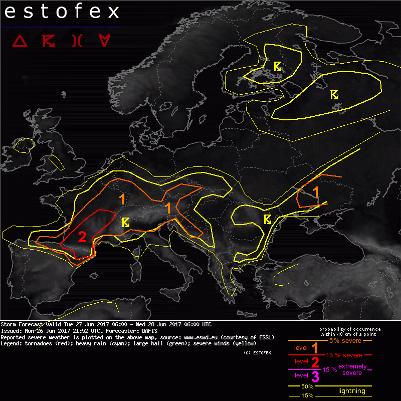
(C) ESTOFEX European Storm Forecast Experiment. Forecast by DAFIS.
ESTOFEX decided to issue a level 2 for northeastern Spain and parts of France, with the main risks being severe wind gusts, excessive rainfall and large hail.
A level 1 was issued for N Spain, France, Switzerland, Germany, Austria, S Belgium, Luxemburg and the Czech Republic, with the main risks being severe wind gusts, large hail and excessive precipitation.
A level 1 was also issued for N Italy, Slovenia, Croatia and Bosnia-Herzegovina, with the main risks being severe wind gusts and excessive precipitation, as well as a
level 1 for E Ukraine and SW Russia, with the main risk being excessive precipitation.
Thunderstorms are likely throughout northern Spain, France and much of central Europe (except the Netherlands and northern Germany), and the Balkans today, as well as parts of Bulgaria, Romania, Moldova, Ukraine and Russia.
|
|
by Linus
25.12.2016 07:43
|
|
This is the ESC European Windstorm Overview, Issued at 0630UTC on the 25.12.2016
There is currently 1 storm system in the region.
Storm BARBARA, currently just to southwest of Iceland with a central pressure of 961hPa is moving towards Europe. It is currently the only storm system watched by ESC in Europe. BARBA is expected to bring hurricane-forced gusts to parts of Europe. A severe storm warning was issued for the northern parts of Ireland and the UK, where gusts above 125km/h are to be expected in the passage of the storm's fronts today. The highest wind speeds, in part above 180km/h, are to be expected on exposed mountaintops in Scotland. A severe storm warning was also issued for the islands of the North Sea, where gusts may exceed 150km/h as the storm field moves through towards Scandinavia. Storm gusts are also to be expected in the rest of Ireland and the UK, Iceland, mainland Denmark, the North Sea coast of the Netherlands and Germany within 24 hours. BARBARA is expected to cross Scandinavia tomorrow, making a severe storm watch necessary for all of southern Norway and Sweden and some of the Baltic islands, and a regular storm watch for the remaining Baltic islands as well as the eastern and southern Baltic coasts and some of mainland Germany. See the warnings and watches map below for details.
BARBARA's current peak gusts of today:
181km/h - Cairngorn Mountains, UK
165km/h - Cairnwell, UK
154km/h - Aonach Mor, UK
Below are the ESC Overview and warnings / watches maps:


|
|
by Linus
21.12.2016 10:30
|
|
This is the ESC European Windstorm Overview, issued at 0930UTC on the 21.12.2016.
There is currently 1 storm system in the region.
Storm ZARINA is located in the far north of the North Sea, with a central pressure of currently only 942hPa. A peak gust of 166km/h has been registered in Norway. ZARINA is currently battering the west coast of Norway and some North Sea Islands with hurricane-forced winds - ESC has therefore issued a severe storm warning for those regions. The storm is also impacting the rest of the North Sea, Iceland as well as the northern parts of the UK and Ireland; regular storm warnings were issued for these regions. As ZARINA continues to move towards the northeast, wind speeds will pick up in the Baltic within the next 24 hours as well, making a storm warning necessary for some land masses adjacent to the ocean. It is possible that storm gusts occur at the southern coast of Norway and in Denmark towards the end of the 24-hour forecast period, hence a storm watch has been issued for these regions.
Below are the ESC Overview as well as the warnings and watches maps.


Dark red: Severe storm warning (>120km/h likely within 24h)
Red: Storm warning (>70km/h likely within 24h)
Yellow: Storm watch (>70km/h possible within 48h)
|
|
by Linus
20.12.2016 10:04
|
|
This is the ESC European Windstorm Overview, Issued at 0750UTC on the 20.12.2016
There are currently two storm systems in the region.
Severe storm XENIA is located near Iceland with a central pressure of 945hPa and peak gusts exceeding 145km/h. Its storm field is currently affecting Iceland and will move across the UK, Ireland, the North Sea Islands and to the coast of Norway in the coming hours. Hurricane-forced gusts are to be expected in Iceland, the northern UK, the North Sea Islands and Norway's coast - severe storm warnings have been issued for those regions. In Ireland and parts of the central UK, storm gusts are to be expected and hence a storm warning was issued. The storm may affect the Baltic between 24 and 48 hours from now, however due to uncertainties in the forecast and the time span in which this may happen, only a storm watch has been issued for the islands in the Baltic.
Another storm is currently located in the western Mediterranean, with a central pressure of 1002hPa and peak gusts of over 115km/h. The main threat from this system, however, is excessive precipitation. ESC has issued a storm warning for the Baleares, far southern France, Corsica, Sardinia and Sicily. The storm is forecast to weaken in the coming 24 hours, and no storm watches are necessary.


Dark red: Severe storm warning (>120km/h within 24h likely)
Red: Storm warning (>70km/h within 24h likely)
Yellow: Storm watch (>70km/h within 48h likely)
|
|
by Linus
14.12.2016 17:46
|
|
This is the ESC European Windstorm Overview, issued 2016.12.14 at 1630UTC.
There are currently two storm systems in the regions.
Severe storm XENIA is located to the southeast of Iceland with a central pressure of 973hPa and peak gusts exceeding 130km/h. It is currently affecting Iceland, the North Sea Islands and possibly the coast of Norway. The storm is expected to weaken and ultimately dissipate as it moves in a northerly direction and away from land masses. Due to uncertainties in the size of XENIA’s storm field, a storm watch has been issued for the coast of Norway.
A nameless severe storm is located over the central northern Atlantic, with a central pressure of only 959hPa and peak gusts exceeding the impressive value of 160km/h. It is forecast to move further to the northeast but weaken on the way. Iceland should nonetheless brace for gusts above 110km/h from this storm within the 24-48hours. Due to the possibility of storm gusts in northwestern Ireland and the northwestern UK, a storm watch has been issued for those regions as well.
Below are the ESC Overview- as well as the Warnings and Watches Maps.


|
|
by Linus
12.12.2016 17:43
|
|
This is the ESC European Windstorm Overview, issued 12.12.2016 at 1630UTC.
There are currently two storm systems in the region.
Storm WALTRAUD is located at the northeastern tip of Iceland, currently with a central pressure of 980hPa and peak gusts exceeding 115km/h. The storm is currently affecting Iceland, hence a storm warning has been issued for that island. No other land masses are expected to be in WALTRAUD's storm field within the forecast period.
A nameless severe storm is located over the northern Atlantic, moving to the north. It currently has a central pressure of 960hPa and peak gusts exceeding 140km/h. Its storm field is expected to extend over Iceland, Ireland, the UK and the North Sea islands within the 48-hour forecast period needed for a watch to be issued.
Below are the ESC European Storm Overview and Warnings / Watches maps:


|
|
by Linus
16.11.2016 03:37
|
|
This is the ESC European Windstorm Overview, issued at 02:00am on the 16th of November, 2016.
Severe storm MIRJA is located just to the northwest of Iceland with a central pressure of 966hPa at the 18UTC analysis. Peak gusts in the system currently exceed 170km/h, making it fit for the classification as "severe storm". The system is forecast to gradually move to the east, and within the next 24 hours will (in some regions continue to) affect Iceland, Ireland, the UK and the North Sea Islands. At the beginning of the forecast period, in the coming few hours, the possibility of severe storm gusts especially at the southwestern coast of Iceland is given. A storm warning has been issued for all of the above regions, in southwestern Iceland it overlays a severe storm watch.
Peak gusts registered in relation to storm MIRJA in the past 24h:
154km/h in Cairngorn Mountains, UK
133km/h in Juvvasshoe, Norway
Storm LAURA is located at the northwestern coast of Norway. It currently has a central pressure of 965hPa, and peak gusts exceeding 105km/h. Within the next 24 hours, it will continue to move towards the east and quickly lose intensity; however especially at the beginning of the forecast period, storm gusts are to be expected in northern Norway, northern Sweden and northern Finland. Storm warnings have been issued for the respective regions.
A storm watch has been issued for the northern coast of France, for Belgium, the Netherlands and the North Sea Coast of Germany regarding severe storm MIRJA, the storm field of which is expected to shift further to the south between 24 and 48 hours from now. Due to the time frame and the fact that there are still uncertainties regarding the intensity and distribution of the storm field, a storm watch has been issued for the regions stated above.
Below are today's ESC Overview, as well as the warnings and watches.


Red: Storm warning (>70km/h likely within 24h)
Orange: Severe storm watch (>120km/h possible within 48h)
Yellow: Storm watch (>70km/h possible within 48h)
|
|
by Linus
13.11.2016 21:06
|
|
Here is today’s ESC European windstorm overview, issued November 13th 2016 at 20:00 UTC.
There is currently one storm system in the region.
A nameless severe storm is located near Iceland, with a central pressure of currently 964hPa and peak gusts exceeding 120km/h. The storm center is forecast to move towards the northeast, and the wind field will intensify before making landfall in Scandinavia. Currently, this severe storm is affecting Iceland, Ireland, the UK and the North Sea Islands (storm warnings have been issued for these regions), however it is forecast to strike the west coast of Norway and the north of the Scandinavian peninsula with hurricane-forced storm gusts within the next 24 hours, hence a severe storm warning has been issued for those regions.
Below are the ESC Overview as well as warnings and watches:

Red: Storm warning (>70km/h likely within 24h)
Dark red: Severe storm warning (>120km/h likely within 24h)

|
|
by Linus
30.10.2016 12:08
|
|
Here is today’s ESC European windstorm overview, issued October 30th 2016 at 11:00 UTC.
There is currently one storm system in the region.
Severe storm GISI has regained strength and is now located to the northwest of Iceland with a central pressure of 993hPa, 4hPa higher than in the previous ESC overview. The system’s peak gusts currently exceed 140km/h, but this is mainly over the open ocean between Iceland and Greenland. GISI is currently affecting Iceland with storm gusts that are forecast to intensify in the coming hours, hence a storm warning has been issued which overlays a severe storm watch on the map. Some northern islands of the North Sea may also be affected within the next 48 hours, but due to uncertainties and the time period a storm watch watch has been issued.
Below are the ESC Overview as well as warnings and watches:


Red: Storm warning (>70km/h likely within 24h)
Orange: Severe storm watch (>120km/h possible within 48h)
Yellow: Storm watch (>70km/h possible within 48h)
|
|
by Linus
29.10.2016 14:28
|
|
Here is today’s ESC European windstorm overview, issued October 29th 2016 at 12:00 UTC.
There are currently two storm systems in the region.
Storm FLORENTINE has weened and is now located over Finland, with it's main wind field over souther Scandinavia and a central pressure of 993hPa. The system’s peak gusts currently exceed 90km/h, however especially in exposed locations the gusts may stronger. FLORENTINE has significantly weakened since the last ESC Overview, and is now only responsible for isolated storm gusts in southern Scandinavia and possibly along the Baltic Coasts. Therefore, instead of warnings, ESC has decided to issue storm watches regarding FLORENTINE.
Storm GISI has also weakened and is now located to the south of Iceland with a central pressure of 989hPa. The system’s peak gusts currently exceed 105km/h. GISI is not affecting any land masses at the moment, but will move towards the northeast and will affect Iceland and the northern North Sea within the next 24 hours. Especially in Iceland, there may be hurricane-forced gusts, as GISI is expected to intensify as it comes closer. Therefore a storm warning has been issued for Iceland and northern North Sea islands, and a severe storm watch (covered by the warning on the map) has been issued for Iceland.
Below are the ESC Overview as well as warnings and watches:


Orange: Severe storm watch (>120km/h possible within 48h)
Red: Storm warning (>70km/h likely within 24h)
Yellow: Storm watch (>70km/h possible within 48h)
|
|
by Linus
28.10.2016 13:20
|
|
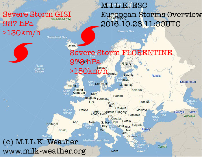
Here is today’s ESC European windstorm overview, issued October 28th 2016 at 11:00 UTC.
There are currently two storm systems in the region.
Severe storm FLORENTINE is located to the north of Iceland with a central pressure of 978hPa. The system’s peak gusts currently exceed 150km/h, however especially in exposed locations the gusts may stronger. FLORENTINE is currently affecting Iceland, the North Sea, the UK, the coasts of the Baltic and Norway; storm warnings have been issued for the regions affected. Further, the storm field will move across Scandinavia and into the Baltic sea within the next 24 hours, possibly bringing storm gusts to large parts of Scandinavia very soon - storm warning have been issued. Below are some of today’s peak gusts of severe storm FLORENTINE:
- 133km/h, Cairgorn Mountains, UK
- 126km/h, Svinoy, Norway
- 119km/h, Skamdal, Norway
A new severe storm has entered the ESC overview. Severe storm GISI is located over the northern Atlantic with a central pressure of 987hPa. The system's peak gusts currently exceed 130km/h. GISI is not affecting any land masses at the moment, but will move towards the northeast and may affect Iceland within the 48-hour forecast period; due to uncertainty in the forecast and possible lack of intensity at the time, no storm watch has been issued.

|
|
by Linus
27.10.2016 16:56
|
|
Here is today’s ESC European windstorm overview, issued October 27th 2016 at 11:30 UTC.
There is currently one storm system in the region.
Severe storm FLORENTINE is located near Iceland. The system's peak gusts currently exceed 135km/h, however especially in exposed locations the gusts may be a lot stronger. FLORENTINE is currently affecting Iceland, the North Sea, Ireland, the UK and Norway; storm warnings have been issued for the regions affected. Further, the storm field will move across Scandinavia and into the Baltic sea within the next 24 to 48 hours, possibly bringing storm gusts to the coasts of the Baltic as early as in 12 hours - due to uncertainties in the prediction and the time period, a storm watch rather than a warning has been issued for the coats of the Baltic sea and southern Sweden. Below are some of today's peak gusts of severe storm FLORENTINE:
- 161km/h - Cairgorn Mountains, UK
- 157km/h - Juvvasshoe, Norway
- 143km/h - Cairnwell, UK
- 140km/h - Myken, Norway
- 137km/h - Krakenes, Norway
- 133km/h - Svinoy, Norway
- 130km/h - Aonach Mor, UK
Below are the ESC overview as well as warnings/watches maps.

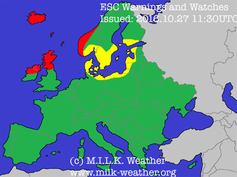
Red: Storm warning (>75km/h likely within 24h)
Yellow: Storm watch (>75km/h possible within 48h)
|
|