Blog Categories
Most popular blog posts
Like this Blog
Latest blog posts
Latest blog comments
Most active Bloggers
Categories
|
|
by Linus
24.10.2016 13:45
|
|
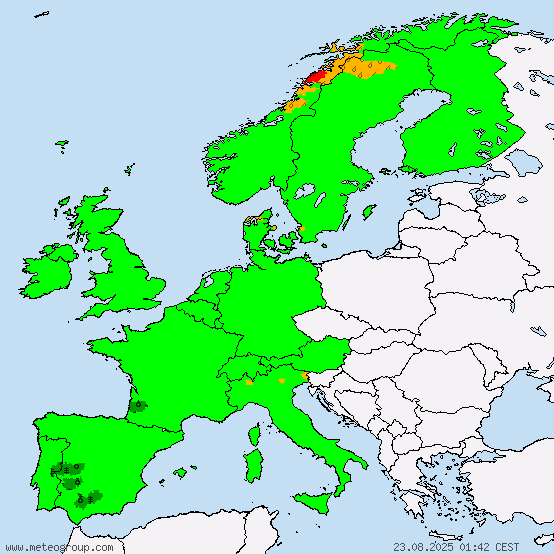
Here is today’s ESC European windstorm overview, issued October 24th 2016 at 11:35 UTC.
There are currently two storm systems in the region.
Storm ELISABETH is located to the west of the Iberian peninsula. Its central pressure is 991hPa, peak gusts currently exceed 95km/h. The system is forecast to remain more or less stationary to the west / southwest of Portugal. ELISABETH's storm field is not predicted to affect any land masses within the next 48 hours, hence no warnings or watches have been issued.
A new, nameless storm is located in northeastern Canada. Peak gusts currently exceed 105km/h. As of now, the storm field of this low pressure system is not affecting any European land masses, but storm gusts of around 100km/h are possible in Iceland in about 30 hours and later on other islands in the North Sea and possibly the northern tip of the UK. Therefore, a storm watch has been issued for these regions regarding this new storm.
Below are the ESC overview as well as warnings/watches maps.

Yellow: Storm watch (>70km/h possible within 48h)
|
|
by Linus
22.10.2016 13:46
|
|
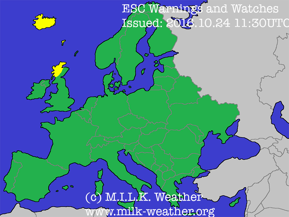
Here is today’s ESC European windstorm overview, issued October 22nd 2016 at 11:30 UTC.
There are currently two storm systems in the region.
Severe storm NICOLE is located near the east coast of Greenland. Its central pressure is 981hPa, peak gusts currently exceed 135km/h. A gust of 83km/h has been registered in Greenland. The system is forecast to remain more or less stationary between the eastern coast of Greenland and Iceland. NICOLE's storm field may affect Iceland early in the 24-hour forecast period, however there are big uncertainties with the forecast and hence ESC only issued a storm watch for Iceland.
A new, nameless storm is located between to the northwest of Portugal and southwest of Ireland. Its central pressure is 993hPa, and this is the first ESC overview in which this storm is being tracked. Peak gusts currently exceed 115km/h. As of now, the storm field of this low pressure system is not affecting land masses, but it is forecast to strike the southwest of the UK and the far NW of France with gusts of up to 85km/h within the next 24 hours, therefore a storm warning has been issued for the region. Storm watches have been issued for southern Ireland, southern UK, the west coast of France and parts of the northern coast of Spain because there may be storm gusts in these regions within the next 48 hours due to this new system.
Below are the ESC overview as well as warnings/watches maps.

Red: Storm warning (>70km/h likely within 24h)
Yellow: Storm watch (>70km/h possible within 48h)
|
|
by Linus
20.10.2016 00:01
|
|
Here is today’s ESC European windstorm overview, issued October 19th 2016 at 21:40 UTC.
There is currently one storm system in the region.
Severe storm NICOLE is located over the Northern Atlantic to the east of Greenland and west-southwest of Iceland. Its central pressure is 961hPa, a decrease of 5 hPa since the last ESC overview at 10UTC, peak gusts currently exceed 130km/h. A gust of 107km/h has been registered in Iceland, in Greenland a wind peak of 126km/h has been registered. The system is forecast to move towards the north, and its center is predicted to reach the coast of Greenland within 24h. NICOLE is forecast to affect Iceland within the 24-hour forecast period. Hurricane-forced storm gusts over 135km/h, possibly more, are to be expected as the storm fiel moves across the Island in the coming 24h. Exposed places such as mountain peaks and coasts are especially at risk. A severe storm warning has been issued for Iceland due to the imminent threat from the severe storm NICOLE. Outskirts of NICOLE’s storm field will also affect the northern North Sea, hence a storm warning has been issued for the islands located there.
Below are the ESC overview as well as warnings/watches maps.


Dark red: Severe storm warning (>120km/h likely within 24h)
Red: Storm warning (>70km/h likely within 24h)
|
|
by Linus
19.10.2016 13:40
|
|
Here is today’s ESC European windstorm overview, issued October 19th 2016 at 11:25 UTC.
There is currently one storm system in the region.
Severe storm NICOLE is located over the Northern Atlantic to the southeast of Greenland and southwest of Iceland. Its central pressure is 966hPa, a decrease of 2 hPa since the last ESC overview, peak gusts currently exceed 120km/h. The system is forecast to move towards the north, and its center is predicted to reach the coast of Greenland in 24h. NICOLE is forecast to affect Iceland within the 24-hour forecast period. Hurricane-forced storm gusts over 135km/h, possibly more, are to be expected as the storm fiel moves across the Island in the coming 24h. Exposed places such as mountain peaks and coasts are especially at risk. A severe storm warning has been issued for Iceland due to the imminent threat from the severe storm NICOLE. Outskirts of NICOLE's storm field will also affect the northern North Sea, hence a storm warning has been issued for the islands located there.
Below are the ESC overview as well as warnings/watches maps.


Dark red: Severe storm warning (>120km/h likely within 24h)
Red: Storm warning (>70km/h likely within 24h)
|
|
by Linus
18.10.2016 14:40
|
|
Here is today’s ESC European windstorm overview, issued October 18th 2016 at 10:20 UTC.
There is currently one storm system in the region.
Severe storm NICOLE is located over the Northern Atlantic. Its central pressure is 968hPa, peak gusts currently exceed 140km/h. The system is forecast to move towards roughly the north at a high speed, and is forecast to affect the west of Iceland towards the end of the 24-hour forecast period. Hurricane-forced storm gusts over 120km/h, possibly more, are to be expected and as the storm moves closer the wind speeds will likely further pick up (within the 48-hour forecast period). A severe storm warning has been issued for western Iceland due to the imminent threat from the severe storm NICOLE. Later during the forecast, on the second day, the storm is forecast to batter all of Iceland with severe storm gusts. Therefore, a severe storm watch has been issued for Iceland. Towards the end of the forecast period, NICOLE may also affect islands in the northern North Sea. Hence a storm watch has been issued there.
Below are the ESC overview as well as warnings/watches maps.

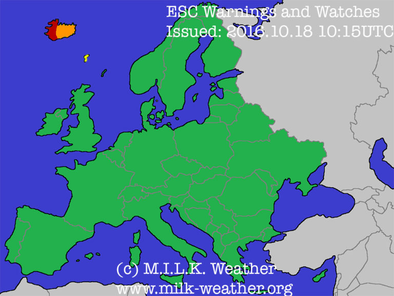
Dark red: Severe storm warning (>120km/h likely within 24h)
Orange: Severe storm watch (>120km/h possible within 48h)
Yellow: Storm watch (>70km/h possible within 24h)
|
|
by Linus
08.10.2016 13:51
|
|
Here is today’s ESC European storm overview, issued October 7th 2016 at 20:00 UTC.
There is currently 1 nameless storm in the region. Its central pressure is 987hPa, a peak gust of 102km/h has been registered in Iceland. The system is forecast to slowly move towards Iceland in the upcoming days, and is already affecting the island with peak gusts over 100km/h. Most affected is the southwestern coast.
Below are the ESC overview as well as warnings/watches maps.


|
|
by Linus
25.06.2016 09:32
|
|
EARLY WARNING regarding THUNDERSTORMS
Valid for: Berlin, Potsdam-Mittelmark, Potsdam
Valid from: 2016.06.25, 10:00 CEST
Until: 2016.06.26, 08:00 CEST
Issued by: Linus H. for M.I.L.K. Weather (www.milk-weather.org / www.milk-stormchasers.de)
At: 2016.06.25, 09:00 CEST
Over the course of the day, showers and thunderstorms will form and move towards northerly or northeasterly directions. Many of the thunderstorms will have the potential to become severe, as there is a lot of energy in the atmosphere with temperatures reaching maxima of up to 32°C and high dewpoints of currently around 18°C. The first thunderstorms may still start forming in the later morning hours, but formation will continue throughout the day and into the night, with the thunderstorm activity decreasing in the second half of the night.
The main risks of today’s thunderstorms will be the following:
- Flash flooding. Rainrates of 40l/m² within an hour will not be uncommon in today’s thunderstorms, and powerful storms may reach up to 80l/m² within an hour.
- Storm gusts. Storm gusts will, in most thunderstorms exceed 80km/h and in extreme thunderstorms may reach values as high as 120km/h.
- Hail. Hail has been a main issue in the thunderstorms throughout western Germany in the previous days, and the forecasts show that this trend is likely to continue. Hail up to 4cm in diameter might fall from severe thunderstorms.
- Tornados. The chance for tornado formation is slightly increased today, and it cannot be ruled out that a tornado even will take place in a thunderstorm somewhere throughout eastern Germany this afternoon / evening. Please note that a tornado is a fairly rare and very local event and hence is difficult to predict and track. It is likely that there will not be a tornado today, but the possibility cannot be ruled out.
When a thunderstorm approaches, stay inside, close all windows and doors. Secure loose objects on balconies / in gardens. Prepare for possible damages and power outages. Unplug electronic devices. If possible, take measures against flash flooding.
+++++++++++++++++++++++++++++++++
VORWARNUNG vor GEWITTERN
Ausgegeben für: Berlin, Potsdam-Mittelmark, Potsdam
Gültig ab: 2016.06.25, 10:00 MESZ
Bis: 2016.06.26, 08:00 MESZ
Ausgegeben von: Linus H. für M.I.L.K. Weather (www.milk-weather.org / www.milk-stormchasers.de)
Um: 2016.06.25, 09:00 MESZ
Im Laufe des Tages werden sich Gewitter durch das Vorhersagegebiet in nördliche oder nordöstliche Richtungen verlagern. Viele der Gewitter haben das Potential unwetterartig auszufallen, da heute mit Höchstwerte von bis zu 32°C und Taupunkten von aktuell rund 18°C viel Energie in der Luft vorhanden ist. Die ersten Gewitter könnten sich schon am Vormittag bilden, weitere werden sich aber auch am Nachmittag und in der Nacht bilden. Die Gewittertätigkeit wird voraussichtlich erst in der zweiten Nachthälfte nachlassen.
Die Hauptgefahren in den heutigen Unwettern sind die folgenden:
- Starkregen. Regenraten von 40l/m² werden in den heutigen Gewittern nichts Ungewöhnliches sein, und kräftige Unwetter können bis zu 80l/m² pro Stunde erreichen.
- Sturmböen. In den meisten Gewittern ist mit Sturmböen über 80km/h zu rechnen und in besonders extremen Zellen können die Böen auch bis zu 120km/h erreichen.
- Hagel. Hagel war in den Unwettern in anderen Teilen Deutschlands der vergangenen Tage immer ein wichtiger Faktor, und die Vorhersagen zeigen, dass dieser Trend sich heute voraussichtlich fortsetzen wird. In Unwettern kann es Hagel mit Korngrößen von bis zu 4cm geben.
- Tornados. Die Gefahr vor Tornados ist heute etwas erhöht, und so kann es nicht ausgeschlossen werden, dass im Verlauf des Nachmittags oder Abends irgendwo in Ostdeutschland ein Tornado auftritt. Bitte beachten Sie das Tornados recht seltene und sehr lokale stürme sind und somit sehr schwierig vorherzusagen und zu verfolgen sind. Es ist wahrscheinlich dass heut kein Tornado auftreten wird, aber die Möglichkeit kann nicht ausgeschlossen werden.
Sollte ein Gewitter aufziehen, bleiben Sie drinnen, schließen sie alle Fenster und Türen. Sichern sie lose Objekte auf Balkonen / im Garten. Bereiten Sie sich auf mögliche Schäden und Stromausfälle vor. Stecken Sie elektrische Geräte ab. Falls möglich, führen sie präventive Maßnahmen gegen Überflutungen aus.
|
|
by Linus
24.06.2016 06:05
|
|

The very dangerous setup in central Europe will continue to produce thunderstorms today, many of which may become severe. Currently there are still some strong thunderstorms ongoing in western Germany.
The focus of thunderstorms in Germany will be in a diagonal line more to the center today, with the most severe thunderstorms expected to form in the northeast and the southwest. In Germany, large hail with a diameter of 5cm or even greater will be the main risk again, accompanied by storm gusts up to 100km/h and intense rain of over 40 l/m² in an hour or less. There is also an increased chance for tornadoes.
In the southeast of the forecast region, the main risk will be strong rain, but large hail may also be caused by the storms in that region.
|
|
by Linus
23.06.2016 18:46
|
|
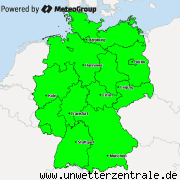
Mit Böen bis 100km/h, Starkregen bis 45l/m² in 1h und Hagel bis 4cm Durchmesser derzeit Gewitter in NRW mit Kurs auf Osnabrück
[[File:zsweeps_2016_06_23_16_40_5257_258.png|none|fullsize]]
|
|
by Linus
23.06.2016 18:40
|
|
Gewitter in NRW jetzt mit Böen bis 90km/h, Starkregen und Hagel bis 2cm. Zugrichtung: NO.
[[File:zsweeps_2016_06_23_16_35_5257_258.png|none|fullsize]]
|
|
by Linus
23.06.2016 18:26
|
|
Auch in NRW ein Gewitter mit Sturmböen bis 70km/h, Starkregen und möglicherweise kleinem Hagel

|
|
by Linus
23.06.2016 10:54
|
|
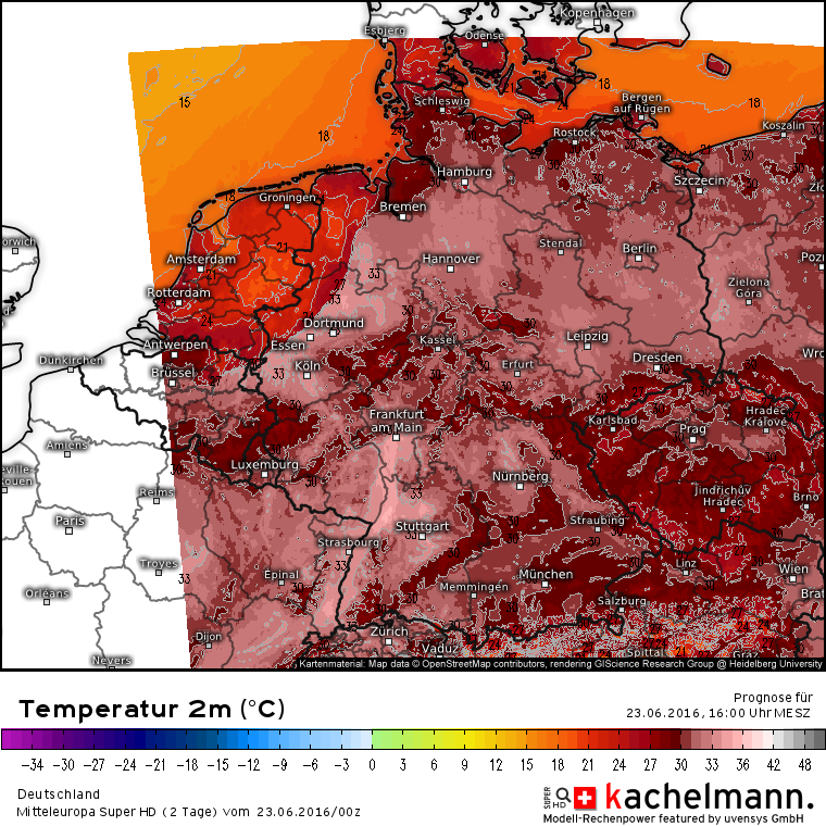
In Deutschland kommt heute - zumindest für ein paar Tage - der Sommer an. Die Temperaturen werden heute im ganzen Land teils deutlich über 30°C steigen. Somit ist auch eine große Hitzebelastung zu erwarten, die besonders für alte und kranke/schwache Personen durchaus auch gefährlich sein kann. Außerdem ist mit starker UV-Belastung zu rechnen.
Die Temperaturen können bis zum Anfang der neuen Woche lokal bis zu 36°C erreichen. Hier die Hitzeschwepunkte in den kommenden Tagen:
Donnerstag: Bundesweit, vor allem NW
Freitag: Bundesweit außer NW, vor allem O
Samstag: Osten
|
|
by Linus
30.05.2016 07:00
|
|
EARLY WARNING regarding THUNDERSTORMS
Valid for: Berlin, Potsdam-Mittelmark, Potsdam
Valid from: 2016.05.30, 13:00 CEST
Until: 2016.05.31, 08:00 CEST
Issued by: Linus H. for M.I.L.K. Weather (www.milk-weather.org / www.milk-stormchasers.de)
At: 2016.05.30, 07:00 CEST
Over the course of the day, showers and thunderstorms will form and move across the warning region from the southeast or east towards the northwest or west. The air today will be heated quite substantially (up to 30°C) and the humidity is predicted to remain high. Further, the air will be increasingly instable and a CAPE of up to 1500 J/kg is predicted. Therefore, there is significant potential for thunderstorms and the risk of these to become severe.
The main risk in today’s thunderstorms is flash flooding, which has caused three casualties in southern Germany yesterday. However, there is also a possibility for large hail with a diameter of up to 3cm and storm gusts up to 80km/h, especially ahead of thunderstorms.
Stay inside, close all windows and doors. Secure loose objects on balconies / in gardens. Prepare for possible damages and power outages. Unplug electronic devices. If possible, take measures against flash flooding.
+++++++++++++++++++++++++++++++++
VORWARNUNG vor GEWITTERN
Ausgegeben für: Berlin, Potsdam-Mittelmark, Potsdam
Gültig ab: 2016.05.30, 13:00 MESZ
Bis: 2016.05.31, 08:00 MESZ
Ausgegeben von: Linus H. für M.I.L.K. Weather (www.milk-weather.org / www.milk-stormchasers.de)
Um: 2016.05.30, 07:00 MESZ
Im Tagesverlauf werden sich Schauer und Gewitter bilden, die von Südosten oder Osten über das Warngebiet hinwegziehen. Die Luft wird sich recht stark erhitzen (bis zu 30°C) und die Feuchte wird voraussichtlich recht hoch bleiben. Außerdem wird die Atmosphäre zunehmend instabil und aktuell wird CAPE von etwa 1500 J/kg gerechnet. Somit besteht großes Potential für Gewitter, die zum Teil auch Unwetterartig ausfallen können.
Die Hauptgefahr in den heutigen Gewittern ist Starkregen und somit Überflutungen, wie sie gestern in Süddeutschland drei Leuten das Leben kosteten. Aber auch Hagel mit einem Durchmesser von bis zu 3cm und Sturmböen bis 80km/h (besonders vorderseitig der Gewitter) sind möglich.
Bleiben Sie drinnen, schließen sie alle Fenster und Türen. Sichern sie lose Objekte auf Balkonen / im Garten. Bereiten Sie sich auf mögliche Schäden und Stromausfälle vor. Stecken Sie elektrische Geräte ab. Falls möglich, führen sie präventive Maßnahmen gegen Überflutungen aus.
|
|
by Linus
29.05.2016 09:19
|
|
EARLY WARNING regarding THUNDERSTORMS
Valid for: Berlin, Potsdam-Mittelmark, Potsdam
Valid from: 2016.05.29, 12:00 CEST
Until: 2016.05.30, 08:00 CEST
Issued by: Linus H. for M.I.L.K. Weather (www.milk-weather.org / www.milk-stormchasers.de)
At: 2016.05.29, 09:00 CEST
Over the course of the day, showers and thunderstorms will form and move across the warning region from the southwest towards the northeast. The air today will be heated quite substantially (up to 31°C) and the humidity is predicted to remain high. Further, the air will be increasingly instable. Therefore, there is significant potential for thunderstorms and the risk of these to become severe.
Main risks in today’s thunderstorms are flash flooding and hail, possibly with a diameter of up to 4cm in severe thunderstorms. To a lesser extent, storm gusts are possible at the leading edge of larger thunderstorm complexes. The possibility of a tornado in exceptionally well-structured thunderstorms cannot be ruled out completely, either.
Stay inside, close all windows and doors. Secure loose objects on balconies / in gardens. Prepare for possible damages and power outages. Unplug electronic devices. If possible, take measures against flash flooding.
+++++++++++++++++++++++++++++++++
VORWARNUNG vor GEWITTERN
Ausgegeben für: Berlin, Potsdam-Mittelmark, Potsdam
Gültig ab: 2016.05.29, 12:00 MESZ
Bis: 2016.05.30, 08:00 MESZ
Ausgegeben von: Linus H. für M.I.L.K. Weather (www.milk-weather.org / www.milk-stormchasers.de)
Um: 2016.05.29, 09:00 MESZ
Im Tagesverlauf werden sich Schauer und Gewitter bilden, die von Südwesten über das Warngebiet hinwegziehen. Die Luft wird sich recht stark erhitzen (bis zu 31°C) und die Feuchte wird voraussichtlich recht hoch bleiben. Außerdem wird die Atmosphäre zunehmend Instabil. Somit besteht großes Potential für Gewitter, die zum Teil auch Unwetterartig ausfallen können.
Die Hauptgefahren in den heutigen Unwettern sind Überflutungen und Hagel, der in unwetterartigen Gewittern einen Durchmesser von bis zu 4cm erreichen kann. Es besteht außerdem die Möglichkeit von Sturmböen, besonders an der Vorderseite von größeren Gewitterkomplexen. Auch die Formation eines Tornados an einer außergewöhnlich gut strukturierten Zelle kann nicht ganz ausgeschlossen werden.
Bleiben Sie drinnen, schließen sie alle Fenster und Türen. Sichern sie lose Objekte auf Balkonen / im Garten. Bereiten Sie sich auf mögliche Schäden und Stromausfälle vor. Stecken Sie elektrische Geräte ab. Falls möglich, führen sie präventive Maßnahmen gegen Überflutungen aus.
|
|
by Linus
23.05.2016 20:43
|
|
LINK
|
|