Blog Categories
Most popular blog posts
Like this Blog
Latest blog posts
Latest blog comments
Most active Bloggers
Categories
|
|
by Linus
05.07.2015 07:32
|
|
(c) - ESTOFEX
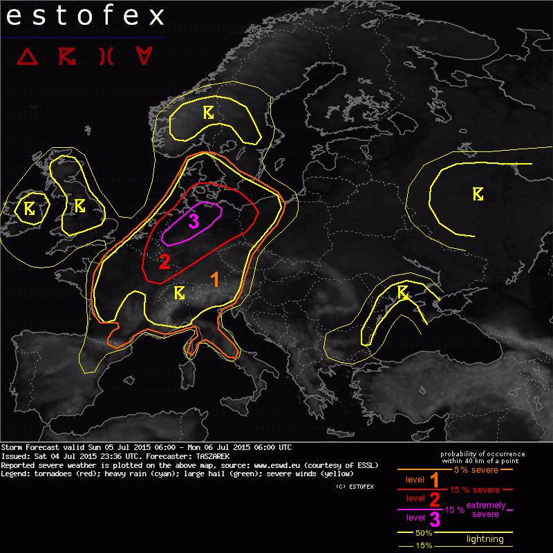
Storm Forecast
Valid: Sun 05 Jul 2015 06:00 to Mon 06 Jul 2015 06:00 UTC
Issued: Sat 04 Jul 2015 23:36
Forecaster: TASZAREK
A level 3 was issued for N Germany mainly for the damaging wind gusts, large and very large hail, tornadoes and excessive precipitation.
A level 2 was issued for parts of Benelux, NE France, S Denmark, NW Poland and parts of Germany mainly for the damaging wind gusts, large and very large hail, tornadoes and excessive precipitation.
A level 1 was issued for France, Denmark, S Germany, W Poland, W Czech Republic, W Austria, parts of Italy and Switzerland mainly for the large hail, severe wind gusts and excessive precipitation.
SYNOPSIS
A ridge with warm and moist tropical air is stretching from Morocco up to Central Europe. Extensive trough with cold front passing through W Europe is placed over N Atlantic. Another trough is placed over NW Russia and provides advection of cold air mass into NE Europe. Most of the S, SE and E Europe is covered with the weak gradient of geopotential and SLP field. The main jet streaks lie over the N France, Northern Sea, N Sweden, Finland and NW Russia. Jet with strong winds at 700 hPa extends from N France up to N Germany. Particularly severe weather is expected in the late afternoon hours over Central Europe where the good overlap of instability, wind shear, moisture and lift will take place.
DISCUSSION
...Central Europe...
It is predicted for tomorrow that within highly unstable tropical air mass with high boundary layer's moisture content (mixing ratio: 13-14 g/kg) and elevated mixed layers from Spain (> 7 C/km) the SB CAPE values in the afternoon hours will reach up to 3000-3500 J/kg. A sharpening gradient of SW flowing mid-level geopotential will cover N France, Benelux and N Germany with DLS up to 20-25 m/s providing significant CAPExSHEAR values. A short wave trough that will provide a great source of lift is predicted by the NWP models to pass through this region in the late evening hours. Apart from that, models are also indicating a thermal low that will develop over NE France and move through Luxemburg up to N Germany will keep surface winds backed. Converging winds along the axis of the trough will provide another source of CI. Since CI within the area of the high shear and instability areas is predicted to be widespread, we issue a level 3. Strong SW flow in mid-levels with locally S and SE inflow of warm and moist air will create a SRH that may reach up to 300 m2/s2 and support the occurrence of dangerous supercellular thunderstorms. SWerly winds at 700 hPa (> 20 m/s) that will be perpendicular to the storm line create also very good conditions for the formation of QLCS that may be capable of producing damaging wind gusts.
Current understanding is that CI will take place in the late afternoon hours over NE France, W Germany and Benelux within the convergence line. From the beginning, the isolated supercells may be capable of producing very large hail and tornadoes. Later on, storms due to a strong lift and shear will cluster into an organized squall line that is predicted to pass through the N Germany. It is likely that such a squall line will contain bow echos and the wind gusts within these may exceed 33 m/s. Since overlap of thermodynamic and kinematic conditions look impressive, the derecho with extreme wind gusts cannot be ruled out. In the southern flank of the storm line, convective mode may remain isolated and thus supercells producing very large hail and tornadoes in central Germany are possible. Supercells are also possible in the N Germany, Benelux and Denmark where they may occur in the front of the squall line. Tornadoes and very large hail are likely if these storms will form. Especially in the evening, when the convective mode will remain isolated and relative humidity will be increasing and thus decreasing the LCL, tornadoes threat will increase. It is difficult to predict in which direction the MCS will exactly move in the evening hours. Some of the models predict it to pass through the Denmark while some forecast that it will enter W Poland. In this forecast, two of these scenarios have been taken into account. The threat degree for the severe weather phenomena occurrence should drop in the night hours when the convection will become elevated.
...Switzerland, W Austria, W Czech Republic, W Poland, S Germany...
In the weakly sheared environment, no good storm organization is predicted. However, locally the high CAPE values (up to 4000 J/kg) may itself create a risk for the occurrence of the large hail and severe wind gusts within the pulse thunderstorms. Since storm motion is weak and the PW values are very large (>40mm), excessive precipitation and local flash flooding cannot be ruled out, especially in the NW Italy and S Germany.
|
|
by Linus
13.06.2015 05:51
|
|
issued by M.I.L.K. Skywatch / Weather
on Saturday, 13.06.2015 at 05:40 MESZ / CET
In the morning no warning relevat weather, in the afternoon partly severe thunderstorms with local strong rain, storm gusts and hail.
Development of the WETHER and WARNING SITUATION within the next 24 hours until Sunday, 14.06.2015, 05:40 :
The front of a low pressure area over the British islands moves over Germany. In front of the front very warm and moist air is brought to Germany.
From noon on, but mainly in the afternoon, THUNDERSTORMS are to be expected from the West. These THUNDERSTORMS have a moderate to high chance to become SEVERE. Main risks are STRONG RAIN (30 to 100mm) bringing BAD VISIBILITY (under 1km), HAIL (4 to 10cm in Diameter) and STORM GUSTS (110 to 180km/h)
Keep yourself updated at www.milk-stormchasers.de / www.milk-weather.org but also at the DWDs official site.
M.I.L.K. Weather, Station 10001, Berlin Steglitz – Linus Höller.
|
|
by Linus
13.06.2015 05:18
|
|
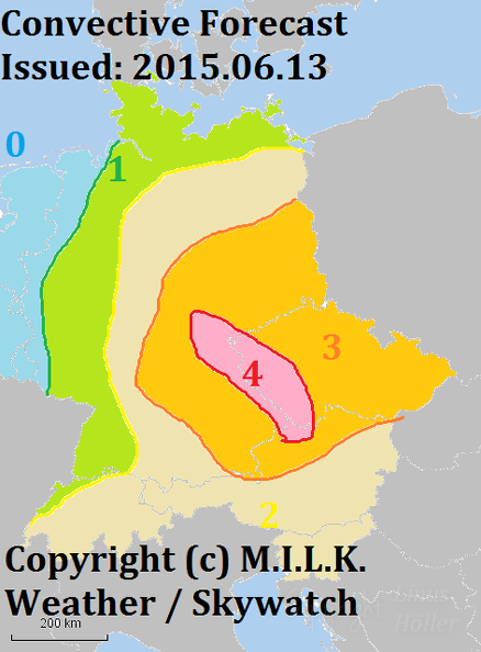
Level 0: Thunderstorms unlikely / Gewitter unwahrscheinlich
Level 1: Thunderstorms possible / Gewitter möglich
Level 2: Thunderstorms likely / Gewitter wahrscheinlich
Level 3: Severe thunderstorms possible / Unwetter möglich
Level 4: Severe thunderstorms likely / Unwetter wahrscheinlich
|
|
by Linus
12.06.2015 06:21
|
|

Level 0: Thunderstorms unlikely / Gewitter unwahrscheinlich
Level 1: Thunderstorms possible / Gewitter möglich
Level 2: Thunderstorms likely / Gewitter wahrscheinlich
Level 3: Severe thunderstorms possible / Unwetter möglich
Level 4: Severe thunderstorms likely / Unwetter wahrscheinlich
|
|
by Linus
11.06.2015 05:43
|
|

Level 0: Thunderstorms Unlikely / Gewitter Unwahrscheinlich
Level 1: Thunderstorms Possible / Gewitter Möglich
Level 2: Thudnerstorms Likely / Gewitter Wahrscheinlich
Level 3: Thunderstorms Likely, Severe Thunderstorms Possible / Gewitter Wahrscheinlich, Unwetter Möglich
|
|
by Linus
06.06.2015 07:33
|
|
issued by M.I.L.K. Skywatch (www.milk-stormchasers.de)
on Saturday, 06.06.2015 at 07:30 MESZ (local time)
Today partly STRONG THUNDERSTORMS with STRONG RAIN, HAIL and STORM GUSTS. Locally EXTREME THUNDERSTORMS are possible.
Development of the weather within 24 hours:
Today a cold front corsses northeast Germany from teh northwest to the southeas. Afterwards, cooler maritime air flows into Germany, that is then affected by a high pressure area from Sunday onwards.
Today THUNDERSTORMS will start forming in the late morning. The THUNDERSTORMS can bring STRONG RAIN around 20 l/m², STRONG STORM GUSTS up to 100km/h (9 to 10 bft) as well as HAIL. SEVERE THUNDERSTORMS with STRONG RAIN over 25 l/m² are possible.
In the night leading to Sunday the THUNDERSTORMS will move away. Until noon on Sunday there no further warning relevant events forecast.
Keep yourself updated on: www.milk-weather.org and www.milk-stormchasers.de
M.I.L.K. Weather, Station 10001 Berlin Steglitz, Linus H.
|
|
by Linus
06.06.2015 07:33
|
|

Level 0: Thunderstorms unlikely / Gewitter unwahrscheinlich
Level 1: Gewitter möglich / Thunderstorms possible
Level 2: Gewitter wahrscheinlich / Thunderstorms likely
Level 3: Thunderstorms likely, partly severe / Gewitter wahrscheinlich, teils stark
Level 4: Thunderstorms likely, mostly severe / Gewitter wahrscheinlich, meist stark
|
|
by Linus
28.05.2015 06:10
|
|
|
|
by Linus
28.05.2015 06:09
|
|
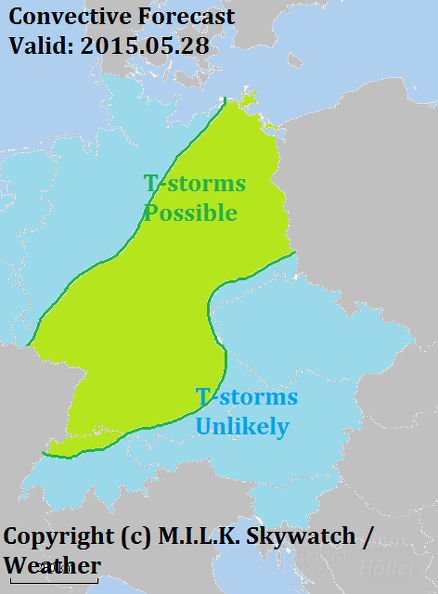
Issued by M.I.L.K. Skywatch
on Thursday, 28.05.2015 at 06:00CEST
In the afternoon and evening locally THUNDERSTORMS possible. Risk will be over after sunset.
Development of the WARNING SITUATION within the next 24 hours until Friday, 29.05.2015:
During the day a front will move through the region. It will bring inconsistant weather.
In the afternoon and evening some local THUNDERSTORMS with wind gusts over 7bft (~55km/h) are expected. The warning-relevant situation should be over by the night.
Updates:
- Convective Forecast issued on www.milk-stormchasers.de
- Automatic weather data and warnings on www.milk-weather.org
Issued by Linus Höller for M.I.L.K. Weather at station 10001, Berlin Steglitz.
|
|
by Linus
12.05.2015 17:57
|
|
Die Kaltfront hat mittlerweile großflächig extreme Gewitter im gepäck. Halten sie sich auf www.milk-weather.org auf dem laufenden!
|
|
by Linus
12.05.2015 16:49
|
|
Die Kaltfront hat nun angefangen teils kräftige Gewitter auszulösen und befindet sich nun ziemlich genau in der Mitte Deutschlands. An der MILK station 10014 in Kleinmachnow frischt der Wind derzeit Ich finde sowieso, dass das jeder so machen soll, wie es zum jeweiligen Kind passt - und das wissen die jeweiligen Eltern normalerweise an besten. ersten Stürmischen Böen auf.
|
|
by Linus
12.05.2015 09:49
|
|
Der DWD (Deutscher Wetterdienst) hat nun vorwarnungen für die Südosthälfte Deutschlands ausgegeben. Es gillt weiterhin, dass eine große Gelfahr am Nachmittag besteht.
The DWD (German Weather Service) has now issued early warnings for the Southeast half of Germany. There is further a big risk in the afternoon.
live information: www.milk-weather.org
|
|
by Linus
12.05.2015 05:56
|
|
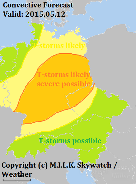
Main risks are: STORM GUSTS over 120km/h
Other risks are: HAIL up to 7cm, STRONG RAIN up to 60l/m², an increased risk for TORNADOS.
Hauptgefahren sind: ORKANBÖEN über 120km/h
Andere Gefahren sind: HAGEL bis zu 7cm, STARKREGEN bis zu 60l/m², eine erhöhe TORNADOGEFAHR.
|
|