Blog Categories
Most popular blog posts
Like this Blog
Latest blog posts
Latest blog comments
Most active Bloggers
Categories
|
|
by Linus
15.04.2016 18:13
|
|
Thunderstorms in E Germany visible from the current satellite image.
Gewitter in Ostdeutschland vom Satellit aus

|
|
by Linus
15.04.2016 17:54
|
|
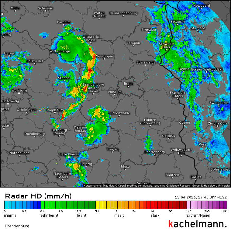
Aktuell bewegen sich durch den Osten Deutschlands Gewitter. Diese verlagern sich in Richtung Osten und können Sturmböen bis 100km/h sowie Starkregen mit sich bringen.
Currently thunderstorms are moving through eastern Germany. The thunderstorms are moving towards the east and can bring storm gusts up to 100km/h as well as strong rain.
|
|
by Linus
05.04.2016 06:48
|
|
ESTOFEX has issued a level 1 severe thunderstorm warning for eastern Germany. The main risks expected are strong winds and, to a lesser extent, large hail. Below is the ESTOFEX map for today.

|
|
by Linus
01.04.2016 06:54
|
|
M.I.L.K. has, again, issued a convective forecast. Thunderstorms are to be expected in Austria south of the main ridge of Alps, in Slovenia, Hungary and locally in Slovakia. Severe thunderstorms are not expected.

|
|
by Linus
31.03.2016 06:39
|
|
M.I.L.K. has released a convective forecast for Central Europe, valid for today. Thunderstorms are possible in southern Germany, Austria north of the Alps, far western Hungary, southern Czech Republic and western Switzerland today. In other regions of central Europe, thunderstorms aren't expected.

|
|
by Linus
29.03.2016 05:34
|
|
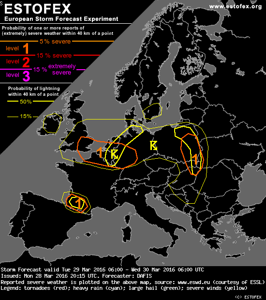
ESTOFEX (European Storm Forecast) has issued a new convective forecast for today. According to the forecast, thunderstorms are most likely in the Benelux states and northwestern Germany, in eastern Poland, Slovakia, Hungary and far western Ukraine, as well as in southwest France. Level 1 warnings were issued for eastern Poland, Slovakia, Hungary and far western Ukraine, as well as for southeast England, the Benelux states and western / central Germany and southwest France. The main risk in thunderstorms throughout Europe today are strong straight-line winds and large hail.
|
|
by Linus
28.03.2016 07:58
|
|
ESTOFEX (European Storm Forecast Experiment) has issued a level one convective weather warning for parts of central Europe today. The warning affects northern France, Belgium, Luxembourg and western and central Germany. The main risks in thunderstorms forming in these areas are isolated tornados and strong straight-line winds. The thunderstorm activity is predicted to increase towards the afternoon, and the convective storms will dissipate after sunset due to the lack of energy.

(c) ESTOFEX
|
|
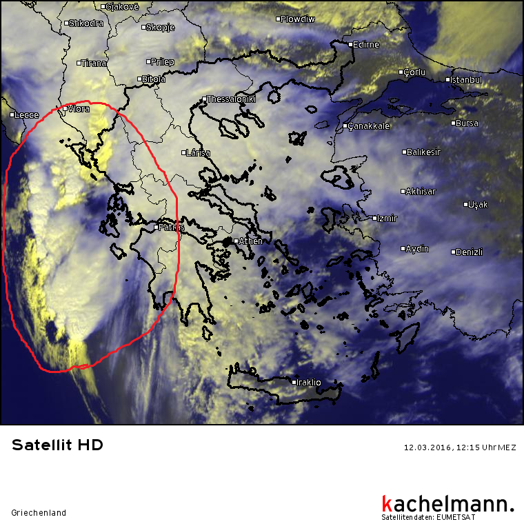
by Linus
12.03.2016 12:36
|
|
The line of thunderstorms that has formed off the western coast of Greece is now starting to gradually make landfall. Currently the extreme northwest of Greece is affected. The main risks to be expected are large amounts of rain and storm gusts. There is also a slightly increased risk of tornados and water spouts.
|
|
by Linus
12.03.2016 09:19
|
|
Along the leading cold front of the low pressure system "Doris", currently located over southern Italy with a central pressure of 1007 hPa, a line of thunderstorms has formed. These thunderstorms are currently lingering off the west coast of Greece, however later today there is still a risk of thunderstorms making landfall in Greece. The main threat coming from these storms are large hail up to 3cm in diameter, and there is also a slightly increased chance for tornados. Especially along the coast there will also be a significant risk of wind gusts. Rain totals may locally, especially in southern Italy, add up to up to 100 l/m².

|
|
by Linus
24.02.2016 06:49
|
|
Even though there is currently a nameless storm to the south of Greenland, there is no risk to Europe according to the current forecasts.


|
|
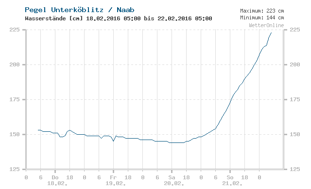
by Linus
22.02.2016 05:46
|
|
Dank der anhaltenden Regenfälle in Deutschland sind einige Flüsse, besonders kleinere, mittlerweile angeschwollen. Lokal regnete es in der vergangenen 48 Stunden über 70 l/m², entsprechend auch die Auswirkungen auf die flüsse.
Die Hochwasserzentralen von Bayern, Brandenburg, Hessen, Niedersachsen, Nordrhein-Westfalen, Rehinland-Pfalz, Saarland, Sachsen-Anhalt und Thüringen haben warnungen ausgegeben.
Ehöhte Waserstände wurden gemeldet aus Schleswig-Holstein, Hamburg, Niedersachsen, Sachsen-Anhalt, Hessen, Thüringen, und Bayern. In Niedersachsen meldet derzeit ein Hochwasserpägel mittleres Hochwasser, in Bayern sind es vier.
|
|
by Linus
22.02.2016 05:28
|
|
Currently there is no storm system in Europe. Locally, there are still storm gusts, for example in parts of northern Germany. But overall the situation is quite relaxed. Below is a GFS analysis.

|
|
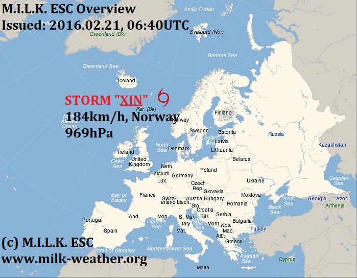
by Linus
21.02.2016 08:02
|
|
Storm XIN remains the only storm affecting Europe. Thanks to this system, a strong westerly flow of air is affecting mainland Europe, bringing storm gusts. Other than the regions affected by this western air flow, Iceland and the islands in the North Sea will also be affected by storm gusts, caused directly by storm XIN.

|
|
by Linus
20.02.2016 08:39
|
|
Good morning! Here is the newest ESC European windstorm overview and warnings/watches. Storm XIN is responsible for quite a bit of wind in Europe within the forecast period, and therefore warnings and watches have been issued. Stay safe!


|
|
by Linus
18.02.2016 11:44
|
|
Storm XIN, currently located over southern Greenland, is predicted to continue to move eastward. Iceland is in the path of the storm, and especially the coasts might be affected by storm gusts over 120km/h within 24h. However, due to uncertainties about where, when and how strong Iceland will be affected, ESC has decided to issue a severe storm watch rather than a warning. Later, Mainland Europe and the British Isles might also be affected by storm gusts over 70km/h - watches have been issued.


|
|