|
This is the ESC European Windstorm Overview, issued at 02:00am on the 16th of November, 2016.
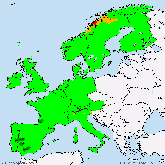
Severe storm MIRJA is located just to the northwest of Iceland with a central pressure of 966hPa at the 18UTC analysis. Peak gusts in the system currently exceed 170km/h, making it fit for the classification as "severe storm". The system is forecast to gradually move to the east, and within the next 24 hours will (in some regions continue to) affect Iceland, Ireland, the UK and the North Sea Islands. At the beginning of the forecast period, in the coming few hours, the possibility of severe storm gusts especially at the southwestern coast of Iceland is given. A storm warning has been issued for all of the above regions, in southwestern Iceland it overlays a severe storm watch.
Peak gusts registered in relation to storm MIRJA in the past 24h:
154km/h in Cairngorn Mountains, UK
133km/h in Juvvasshoe, Norway
Storm LAURA is located at the northwestern coast of Norway. It currently has a central pressure of 965hPa, and peak gusts exceeding 105km/h. Within the next 24 hours, it will continue to move towards the east and quickly lose intensity; however especially at the beginning of the forecast period, storm gusts are to be expected in northern Norway, northern Sweden and northern Finland. Storm warnings have been issued for the respective regions.
A storm watch has been issued for the northern coast of France, for Belgium, the Netherlands and the North Sea Coast of Germany regarding severe storm MIRJA, the storm field of which is expected to shift further to the south between 24 and 48 hours from now. Due to the time frame and the fact that there are still uncertainties regarding the intensity and distribution of the storm field, a storm watch has been issued for the regions stated above.
Below are today's ESC Overview, as well as the warnings and watches.


Red: Storm warning (>70km/h likely within 24h)
Orange: Severe storm watch (>120km/h possible within 48h)
Yellow: Storm watch (>70km/h possible within 48h)
This is the ESC European Windstorm Overview, issued at 02:00am on the 16th of November, 2016.
Severe storm MIRJA is located just to the northwest of Iceland with a central pressure of 966hPa at the 18UTC analysis. Peak gusts in the system currently exceed 170km/h, making it fit for the classification as "severe storm". The system is forecast to gradually move to the east, and within the next 24 hours will (in some regions continue to) affect Iceland, Ireland, the UK and the North Sea Islands. At the beginning of the forecast period, in the coming few hours, the possibility of severe storm gusts especially at the southwestern coast of Iceland is given. A storm warning has been issued for all of the above regions, in southwestern Iceland it overlays a severe storm watch.
Peak gusts registered in relation to storm MIRJA in the past 24h:
154km/h in Cairngorn Mountains, UK
133km/h in Juvvasshoe, Norway
Storm LAURA is located at the northwestern coast of Norway. It currently has a central pressure of 965hPa, and peak gusts exceeding 105km/h. Within the next 24 hours, it will continue to move towards the east and quickly lose intensity; however especially at the beginning of the forecast period, storm gusts are to be expected in northern Norway, northern Sweden and northern Finland. Storm warnings have been issued for the respective regions.
A storm watch has been issued for the northern coast of France, for Belgium, the Netherlands and the North Sea Coast of Germany regarding severe storm MIRJA, the storm field of which is expected to shift further to the south between 24 and 48 hours from now. Due to the time frame and the fact that there are still uncertainties regarding the intensity and distribution of the storm field, a storm watch has been issued for the regions stated above.
Below are today's ESC Overview, as well as the warnings and watches.
Red: Storm warning (>70km/h likely within 24h)
Orange: Severe storm watch (>120km/h possible within 48h)
Yellow: Storm watch (>70km/h possible within 48h)
Most popular blog posts:
|