
Issued 2018.05.15 at 06:00 CEST
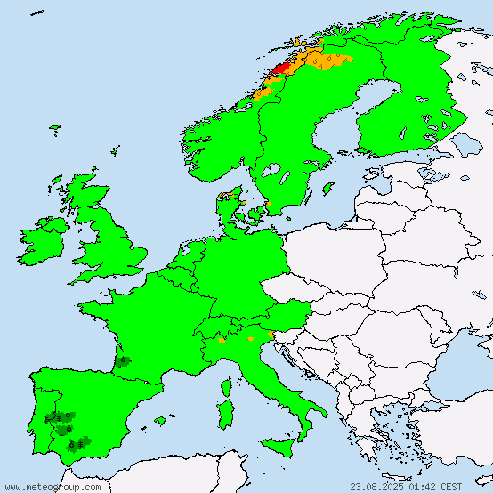
Wide parts of Germany and Central Europe present the right conditions for the formation of thunderstorms today. This is due to the unstable layering of the atmosphere which, in combination with the energy that the sun provides, will lead to the formation of local heat-induced thunderstorms in the afternoon.
Most of these thunderstorms will be rather narrowly confined, meaning that if one town is hit by a thunderstorm, the neighboring town may stay entirely dry.
The general direction the thunderstorms will move across Germany is from Northeast to Southwest.
The main risk stemming from today's thunderstorms is strong rain of between 20 and 40 liters per square meter in short time (under an hour). Flash flooding can take place, which can result in traffic delays and property damage. Further, in and around thunderstorms, storm gusts of up to 70km/h are possible. Also small hail, which will in the most cases not exceed a diameter of 2cm, is not to be ruled out. Hail with more than 2 or 3cm in diameter, tornadoes, as well as strong, structured thunderstorms are unlikely under today's conditions.
If possible, keep yourself informed about the current weather situation.
Below, you will find the "Convective Forecast" for Central Europe.

M.I.L.K. Storm Chasers
Global Weather- and Storm Chasing CommunityX
Replies: 0 • Hits: 2.303
2018.05.15 - Convective Forecast for Central Europe
![]() #1 by
Linus
, Tue May 15, 2018 6:27 am
#1 by
Linus
, Tue May 15, 2018 6:27 am
Linus H - Founder of M.I.L.K. weather 
- Linus

-
Posts: 2.140 Points: 1.549 Date registered 04.09.2012
Replies: 0 • Hits: 2.303
Current warnings


© M.I.L.K. 2017
M.I.L.K. - Meteorology: Information. Learning. Knowledge.
