
2015.03.04.png - Bild entfernt (keine Rechte)
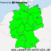
Based on the available data, the risk for the formation of supercells and the weather they bring is highest in central Germany and at the north sea coast/the Netherlands. In central Germany, there is the risk of tornados forming, which already happened in the night to Monday. The other main risk of the thunderstorms today is large hail, however the hail is not forecast to be very large, "only" reaching about 2cm in diameter. Storm gusts up to 90km/h will be possible especially later during the day, after the occlusion has passed in thunderstorms that might form behind the front. The risk of strong rain exists, however is not one of the main risks. Due to only weak instability with a lifted index of -1 and CAPE up to 250, most thunderstorms, if not all, will stay undeveloped. The first thunderstorms are forecast to form around noon, then continue eastward.
Green: thunderstorms possible
Blue: No thunderstorms expected

M.I.L.K. Storm Chasers
Global Weather- and Storm Chasing CommunityX
Replies: 0 • Hits: 993
2015.03.04 - Convective Forecast
![]() #1 by
Linus
, Wed Mar 04, 2015 5:36 am
#1 by
Linus
, Wed Mar 04, 2015 5:36 am
Linus Höller - President of M.I.L.K. weather 
- Linus

-
Posts: 2.140 Points: 1.549 Date registered 04.09.2012
Last edited 03.04.2015 | Top
Replies: 0 • Hits: 993
Current warnings


© M.I.L.K. 2017
M.I.L.K. - Meteorology: Information. Learning. Knowledge.
